← Back

Your message to the BLOGMASTER was sent

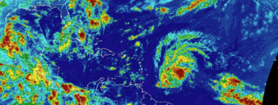
The blogmaster senses from the evidence of recent past and instinct, the weather pattern is changing for the worse as it relates to Barbados. We can debate if God is a Bajan or whether the weather avoids this rock because of natural elements that conspire to  influence the path systems on the approach to the archipelago will track. Whatever the reason we need to do as much planning as it practical to mitigate what is possible.

The most recent satellite image from a credible source is posted for our information. The blogmaster will pinned this post at the top of blog if required.

weather watch.png


Discover more from Barbados Underground

Subscribe to get the latest posts sent to your email.

155 responses to “BB Weather Watch – A Case for Preparation”

  1. Vincent Codrington Avatar
    Vincent Codrington

    @ David BU

    I believe that the Met Office is watching these developing weather systems to the East. By now a pattern should have developed on the likely courses of these systems and the contributing weather elements that will affect their current trajectories and intensities.


  2. @Vincent

    It is not an exact science, the forecasting business that is. They will use different models to attempt to predict, however, nature does not always cooperate.

  3. SirSimpleSimonPresidentForLife Avatar
    SirSimpleSimonPresidentForLife

    And the heat. Whew!!! Sweating while sitting quietly at 7 in the morning is really unfair.

    Lolll!!!

    Probably entirely tron’s fault.

  4. Vincent Codrington Avatar
    Vincent Codrington

    @ Simple Simon

    I agree that is Tron’s fault. He is the best example of a Devil’s Advocate I ever met. He is giving us a foretaste of Hell.


  5. Another sin we can cast at the feet of Tron’s greedy businessmen – CLIMATE CHANGE!


  6. Gheeez, everybody picking on poor Tron. Seems strange Tron has moved above all other political identities for criticism, or is it Friday the 13th hangover from yesterday.

    If GOD’s a Bajan he sure as HELL knows how to pick his politicians, arrogant, corrupt, self serving etc etc.

  7. SirSimpleSimonPresidentForLife Avatar
    SirSimpleSimonPresidentForLife

    Don’t drink. Can’t afford to get drunk, when there are tron’s in this world. They might take advantage. So sober ALL of the time.


  8. Just turn on your AC or move to a reasonable area where the distance between the houses is at least half a mile.

    I am expressly committed to climate change – because DLP is responsible for it. Between 2008 and 2018, they did not take any preventive measures to protect our coasts. This is now taking its toll.


  9. Lord help me some can even blame political parties for bad weather. Lol


  10. @ David.

    On a serious note where are we on the foreign debt restructuring and what’s the real story about Beaches in St Peter. You is a man that can turn over rocks and find facts so as we say ” wha going on dey?”


  11. Also what happening at Sam Lord’s?


  12. @John A

    Waiting but cannot find Hall.


  13. @ David.

    Can’t understanding, hearing about everything and can’t hear a word about nothing important. I mean I hearing bout Rihanna ball and the boss lady being there and all sorts of social activity. Can’t hear no financial info on the topics I mentioned at all at all.

    I say i would ask you cause since the hard times hit I can’t buy a nation every day, so I might of miss it as a result of austerity!


  14. The unofficial word is that there will settle soon, on what we will have to see. You would have heard a leading member of the CTUSAB inquired during the week. Mum is the word.


  15. I shall dub this disease “Trumpenza”. Trump getting more ludicrous. John getting more ludicrous. Tron getting more ludicrous. Did Mia bring that back to Barbados when she met the Orange Peril? Is she just a carrier or does she just have a stronger immune system. Will she be able to fight off the disease?

  16. SirSimpleSimonPresidentForLife Avatar
    SirSimpleSimonPresidentForLife

    The boss lady said “gimme a vote and watch muh”

    We still watching.

    And waiting.

    And waiting

    And waiting.


  17. John A

    Smoke and mirrors, PR stunts, waffle. I would have thought that things in Barbados were such that they needed the undivided attention of the president.
    Remember, after Dorian we heard a lot about climate change. Let us wait and see how long it will take to translate sound bites in to policy. Don’t forget the squatters; and we still have not been told how White Oaks came to the attention of the government.
    Did they approach the government before or after the general election with the default proposal? Has anyone in this government, or its advisers, ever worked with White Oaks previous to the general election? Has anyone associated with this government been paid an introductory fee for the White Oaks deal, or is still being paid??
    Lots of questions, but no answers.


  18. Two day tropical outlook.

    https://www.nhc.noaa.gov/xgtwo/two_atl_2d0.png

    ZCZC MIATWOAT ALL
    TTAA00 KNHC DDHHMM

    Tropical Weather Outlook
    NWS National Hurricane Center Miami FL
    200 PM EDT Sat Sep 14 2019

    For the North Atlantic…Caribbean Sea and the Gulf of Mexico:

    The National Hurricane Center is issuing advisories on Tropical
    Storm Humberto, centered just east-northeast of the northwestern
    Bahamas.

    1. An elongated area of disturbed weather is located about 750 miles
    southwest of the Cabo Verde Islands. Gradual development of this
    system is possible during the next several days, and a tropical
    depression could form by the middle of next week while it moves
    westward across the tropical Atlantic.
    * Formation chance through 48 hours…low…20 percent.
    * Formation chance through 5 days…medium…60 percent.

    2. A large area of cloudiness and showers over the eastern Gulf of
    Mexico is associated with an upper-level low and a weak surface
    trough. Only slow development of this system is likely during
    the next couple of days while it moves westward over the western
    Gulf of Mexico. This system is forecast to move inland along
    the northwestern Gulf coast by late Monday or Tuesday and
    development is not expected after that time.
    * Formation chance through 48 hours…low…10 percent.
    * Formation chance through 5 days…low…30 percent.

    Forecaster Brown


  19. That’s the good new style of government. Transparency, where transparency is necessary. Reports of success instead of daydreams and mere announcements.

    First of all, the government announces that it is getting down to work. After the work is done, there will be a press conference. Nothing is announced that could not be implemented. On the contrary, the ministers are committed to transparency and honesty. Quote from NATIONNEWS on the national stadium: “The reality is the country is in a recession and there is no magic wand we can wave to get out of it, so we have to creep and once everyone understands this, we will get there with a lot less frustration.”

    The behaviour of the old government was very different: First they promised us paradise. Things like “Scandinavian welfare state in the Caribbean”, “economic crisis is over”, “most developed black country” or “Cahill is coming”. Then there was silence. Years later some documents appeared on BU which proved that the government had sold out the country.

    In any case, I am very much looking forward to the debt cut. The new government will once again prove its ability to act and expose the lies of the sneaky opposition in the Senate, in the administration and in the printed and social media.


  20. On another one conspiracy theorist have been saying that globalist geo-engineers are responsible for these cat 5 hurricanes
    My old problem with such theories lends to the fact that in order for such to be probable a link between pressure and steering currents would have to be ajoined which in all probabilty scientist cannot do in a precise manner or effectively


  21. @ Hal.

    Thing is four months ago we were promised an update on the debt restructuring and yet not a squeak. Wait i lie Persaud said ” dont worry we ain’t rushing to pay them as we ain t going borrow from them in no hurry.”

    I would love to know the impact that statement had on the process and how far off are we in settling this issue. If nothing is done private local entities trying to borrow on the international market going smell hell.

    On the Sam Lord’s and Beaches issue seeing that these are 2 pillars of our economic recovery, I expect to be told what’s happening there too.

    All the talk about transparency and interaction with the public like em get suck up in Dorian!


  22. Mind ‘the gap’
    Article by
    Barbados Today
    Published on
    September 14, 2019

    A direct hit from a natural disaster similar to Hurricane Dorian which devastated the Bahamian islands of Abaco and Grand Bahama, would have deadly implications for some low-income Barbadian communities, whose residents should be moved out well before impact.

    And while Executive Director of the Caribbean Disaster Emergency Management Agency (CDEMA) Ronald Jackson has backed recent calls for mandatory building codes, he fears such a process could take over a decade to fully implement.

    In the meantime, he told Barbados TODAY some communities would need to be fully evacuated if a major hurricane threatened the island.

    “The data shows that these events impact those who are deemed to be poor and have very poor infrastructure and you do have pockets of that in this country. So one of the first things you have to look at is how many of these pockets we have, how many people are there and what is going to be the demand on our services because these individuals are likely to be affected and plan for that,” Jackson said after a receiving a donation from the Ocean Hotels for Bahamian citizens affected by Hurricane Dorian.

    “You can save those lives and then we can deal with the infrastructural recovery thereafter, because you very well might lose homes in those particular pockets, but there is no reason why you should lose people. Once we know you are in an inferior housing structure, it is easier for us to evacuate you so you can ride out the storm for a day and go back in, rather than lose your life there. That is what I see in Barbados. Those pockets are potentially your first call,” Jackson suggested.

    The CDEMA executive admitted he was a “hard marker” when assessing disaster-related issues and stressed regional Governments still had a lot to do in the interest of their citizens’ protection.

    “What we have to do is ensure every building is built to code and that we look at the design of the roofing and ensure we are putting in the type of roof design with shorter eves and the type of pitch that will allow the wind forces to go over and reduce pressure on the roofing and there are also some tried and true practices that we have gone away from,” he indicated.

    Jackson however warned that a country’s true level of readiness was not just dependent on the State.

    He pointed to the Bahamian Government, which, according to him had taken all reasonable steps to protect its citizens.

    “We have to become a lot more psychologically ready for the fact that whilst we have been fortunate not to be impacted by anything of any magnitude, we live in a part of the world where these types of things are commonplace and there are changing signatures of tropical storms and extreme weather events.

    “As a people we have to recognise that part of what grants us the beauty that we use for recreation and our economic benefit is also part of what exposes us to the vagaries of natural hazards and events and plan for that,” Jackson said.
    kareemsmith@barbadostoday.bb

  23. Vincent Codrington Avatar
    Vincent Codrington

    The biggest bang for the buck would be to have adequate shelter for those resident in the at risk areas. Shelters built to category 4 hurricane resistant strength.


  24. Agree Vincent, this is what risk mitigation addresses.


  25. You noticed in the aerial videos of the damage that among many of the flattened buildings they were some that were still standing and only had minor damage. If I was involved in the rebuilding I would have to ask what made them stand through it when others didn’t?

    One photo showed what looked like an old church standing firm and surrounded by nothing but flattened houses. It would seem the older houses feared better than some of the newer ones, why?

    That is what needs to be reviewed, what are the common denominators of the houses left standing ?


  26. @ John A September 14, 2019 2:06 PM

    Let’s be serious and impartial: Do you really believe that two lumpy hotels are boosting the economy? We only get underpaid slave jobs there. The income from the hotel contracts all runs offshore, i.e. no inflow of foreign currency.

    We can dream of so many hotel projects. But the slow death of the middle class is inevitable. We have too many doctors, lawyers and other useless professions.

    The middle class only emerged in Barbados because OSA inflated the bureaucracy in an almost perverse way from 1995 onward. Now is the time to apply the needle and let the air out of the balloon.


  27. @ Tron

    I only quoting the words of our leaders who say that ” the tourism sector will form the pillars of our recovery.”

    Never said I agree with them though. However based on THEIR proclamations one would expect some statement on the stalled projects at Sam Lord’s and Beaches don’t you think?

  28. Vincent Codrington Avatar
    Vincent Codrington

    @ John A at 2 :27 PM

    I share your scientific approach to the issue. We can learn a lot from the Dorian catastrophe in Abaco and Grand Bahama Islands in the Bahamas . Preparation. Preparation. Preparation.


  29. Those who witnessed the destruction in Abaco and Grand Bahama would have been influenced by it. It obviously influenced the PM’s press briefing on her return.

    We continue to policitize every issue be it crime, education disaster preparedness the lot.

    Who said we are an educated people? Education is meant to inform best decisions whether to enhance personal or national being.


  30. @ John A September 14, 2019 2:35 PM

    Thank you for pointing that out. Excuse me, please!

    Even if we are paving the entire west and south coast with even more hotels, this doesn’t change the basic problem. Hotels only create jobs in the low-wage sector.

    Offshore banking is dead and no replacement in sight. The state cannot create more sleeping places for civil servants. It won’t take twenty years and the middle class is finally finished.


  31. @ Vincent.

    I think every country in the hurricane belt needs to send a group to Abaco and let them study in real world terms, what the difference was between structural failure and survival. There is no better living example based on fact as opposed to theory, of what is the difference between buildings that survived and those that failed under the presence of the slowest moving cat 5 on record. No amount of simulation can replace the wealth of knowledge that lays entangled in those islands!

    Regardless of what engineers believe, in those islands lies the largest collection of facts that we in this region should harvest prior to their rebuilding. I recall seeing some beach front condos there that stood firm when all around them was destruction. Why?

    There has to be lessons there for all of us, if we just go in there and search for the common denominators those buildings that are standing shared.

    Don’t let that knowledge be lost in the clean up! Of course the learned regional engineers will sit in their airconditioned offices instead and pontificate from their pulpets on what ” should be done based on theory” instead of actually going there and trying to learn from reality.


  32. @ Vincent.

    I would now go further and say the best country to prepare a building code for the region would be the BAahamas post Dorion.

    Their code I would implement as it’s based on reality as opposed to “aircondituoned office theory”.


  33. Those of you living in Barbados should check your own homes and prepare them for a possible Tropical storm or Hurricane this year.

    Stocking cans of corned beef, tuna, sardines and some biscuits etc. should be done now,

    Why wait to join the long lines at the supermarkets when a storm is approaching ?

    Hopefully Barbados will get lucky this year.


  34. @Hants

    This blog is dedicated to you for your relentless focus on disaster preparedness particularly hurricane.

    #thankyou

  35. Vincent Codrington Avatar
    Vincent Codrington

    @ Hants at 3:39 PM

    Hants do you believe the hurricane supplies that Barbadians stocked up last week have been consumed? The Hurricane Season ends at Oct 31st.

    I think the GoB needs to identify more shelters and bring them up to the required standards.Those published seem inadequate to me.

    A traffic plan need to be prepared and published for those who have to evacuate to higher ground. There were too many grid locks prior to shut down last week. Time is usually of essence.

    I ,like David, appreciate your dedication in keeping us, at home, informed and up to date.

  36. Vincent Codrington Avatar
    Vincent Codrington

    @ John A

    I agree with your submission above. There should be an iterative process between theory and data. Scientific progress cannot be made if there are no theories or models. Theories need to be tested with real events / data. It would be interesting to find out how many buildings using the recently discussed building code survived……the buildings with 10 ft square shear walls on each elevation.


  37. @ Vincent.

    Down there lies a wealth of data that all must tap into.


  38. Since the passing of Hurricane Dorian and the seemingly unstoppable destruction unleashed on the islands in the Bahamas; I am of the view that our preparation efforts must now include the thereafter.
    Therefore I believe that in addition to a helmet and waterproof raincoat it should be mandatory for all residents to have a waterproof backpack which should include basic essentials, medicines, torchlight and water to provide some sustenance to survivors until relief efforts reach them or normalcy begins to return


  39. https://www.nhc.noaa.gov/xgtwo/two_atl_2d0.png
    ZCZC MIATWOAT ALL
    TTAA00 KNHC DDHHMM

    Tropical Weather Outlook
    NWS National Hurricane Center Miami FL
    800 PM EDT Sat Sep 14 2019

    For the North Atlantic…Caribbean Sea and the Gulf of Mexico:

    The National Hurricane Center is issuing advisories on Tropical
    Storm Humberto, centered just northeast of the northwestern
    Bahamas.

    1. An elongated area of disturbed weather is located over the central
    tropical Atlantic. This disturbance is currently disorganized and
    only slow development, if any, is anticipated during the next day or
    two. Conditions are then forecast to be conducive for gradual
    development through the middle of next week and a tropical
    depression could form while the system moves slowly westward or
    west-northwestward.
    * Formation chance through 48 hours…low…10 percent.
    * Formation chance through 5 days…medium…60 percent.

    2. A large area of cloudiness and showers over the eastern and central
    Gulf of Mexico is associated with an upper-level low and a weak
    surface trough. Some slow development of this system is possible
    during the next couple of days while it moves westward over the
    western Gulf of Mexico. The system is forecast to move inland
    along the northwestern Gulf coast by late Monday or Tuesday and
    further development is not expected after that time.
    * Formation chance through 48 hours…low…10 percent.
    * Formation chance through 5 days…low…20 percent.

    Forecaster Zelinsky


  40. I put together a single page a while back that displays several Tropical Atlantic related satellite images (GEOCOLOR, IR, Water Vapor, Visible), and a surface analysis image for the same region.

    The code pulls the latest images from NOAA (National Oceanic and Atmospheric Administration, home to the NHC). A ‘thumbnail’ sized image is shown for each view, and just below it, direct links to two larger, high-rez images.

    https://caribbeanweather.org/satellite-images/tropical-atlantic/

    Hope you folks find it useful.

  41. fortyacresandamule Avatar
    fortyacresandamule

    Living on a small low lying island, that is barely less than10ft above sea level in a hurricane zone, is bad enough in itself. Getting struck by a slow moving CAT 5 hurricane with those geographic constrains is a recipe for total destruction. You not only have to worry about the 200mph wind but the more dangerous tsunami-like sea surges.

    To ride out such hazard, a slab roof is a better option. Built far inland with two levels of floor at least 24ft high.


  42. Today’s headline in the Sun HEAT WAVE.


  43. https://www.nhc.noaa.gov/xgtwo/two_atl_2d0.png
    ZCZC MIATWOAT ALL
    TTAA00 KNHC DDHHMM

    Tropical Weather Outlook
    NWS National Hurricane Center Miami FL
    800 AM EDT Sun Sep 15 2019

    For the North Atlantic…Caribbean Sea and the Gulf of Mexico:

    The National Hurricane Center is issuing advisories on Tropical
    Storm Humberto, located more than 100 miles north of the
    northwestern Bahamas.

    1. An elongated area of disturbed weather is located over the central
    tropical Atlantic. Shower activity remains disorganized and only
    slow development, if any, is anticipated during the next day or two.
    However, environmental conditions are forecast to become more
    conducive for gradual development through the middle of the week,
    and a tropical depression is likely to form by the end of the week
    while the system moves slowly westward or west-northwestward.
    * Formation chance through 48 hours…low…10 percent.
    * Formation chance through 5 days…high…70 percent.

    2. A large area of disorganized showers and thunderstorms over the
    central and eastern Gulf of Mexico is associated with an upper-level
    low and a weak surface trough. Some slight development of this
    system is possible during the next couple of days while it moves
    westward over the western Gulf of Mexico. The system is forecast to
    move inland along the northwestern Gulf coast by late Monday or
    Tuesday, and further development is not expected after that time.
    * Formation chance through 48 hours…low…10 percent.
    * Formation chance through 5 days…low…10 percent.

    Forecaster Stewart


  44. From now till early October we have to be watchful for systems forming to the east of us.

    The latitudes which cause us the most problems are 8-11 degrees north.

    If the formation takes place above that band of latitudes and there is no high pressure in the Atlantic to force the system into that band as it travels north west we will be ok.

    But, we need the rain!!

  45. SirSimpleSimonPresidentForLife Avatar
    SirSimpleSimonPresidentForLife

    @TronSeptember 14, 2019 1:08 PM “Just turn on your AC or move to a reasonable area where the distance between the houses is at least half a mile.”

    There is not enough room for all the people in the world to live half a mile apart.

    I don’t wish to contribute to global warming and the use of fossil fuels by using an air conditioner

    And besides I like my neighbours, and they like me.

    I came up with a much BETTER, much WISER solution.

    I took a beach chair outside and lay down on it under some of the trees I planted decades ago. A few glasses of cold water and a book I was good. Going to do the same now.

    My electricity bill hovers around $105. BDS and it is my aim to keep it there.


  46. The simple life sure sounds good!


  47. Thunderstorms are being forecast for tomorrow.

    Full moon was yesterday September 14th, at 12:33 AM.

    We are half way through the month with only a small fraction of the average rainfall we should expect.

    My instincts suggest we should get rain this week and if so there should be not be a heatwave.

    Today, yesterday and last week, now that was a heatwave.

    But, I am not a meteorologist, just going by the numbers, the moon and instincts.

    Plus, I like to think positive.

    By September 29 last year all the ponds in the fields nearby that catch water were full, one in particular remaining with water till February this year.

    This and the rainfall data will be my guage of what sort of troubles the BWA will find itself in in the months to come.


  48. ….. should be not be a heatwave

    ++++++++++++++++++++++++++++++++++++

    should not be a heatwave!!

  49. SirSimpleSimonPresidentForLife Avatar
    SirSimpleSimonPresidentForLife

    Showers off and n this evening, a heavy downpour now. No lightning, no thunder.

The blogmaster invites you to join the discussion.

Trending

Discover more from Barbados Underground

Subscribe now to keep reading and get access to the full archive.

Continue reading