


The events uncovered in the past week has raised more questions about the flyover project in Barbados. We are sorry to disappoint our readers but here we go into Week Two unabated with this story. Coming out of all the research to date about Operation Free Flow aka Flyovers, an interesting nugget of information has surfaced. One of our commenters (Adrian) has picked up on it as well. Surprisingly, we have not heard it mentioned elsewhere. The US company Hills-Carnes Engineering contracted by 3S Barbados SRL to perform foundation testing for the piers (supporting pillars for the flyovers) has indicated that “the limestone rock in this geologic region varies from competent to highly fractured and decomposed. The depths or competent rock ranged from 4 to 30 feet below existing grades.” The good thing is, if we can say so about the recent tragedies which Barbados has suffered lately, it has caused passive Barbadians to begin asking questions. Every where we go in Barbados, we can hear about the existence of caves and deep holes which were previously not mentioned.
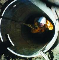
The structural group and the geo-technical divisions are currently working on an extensive flyover bridge system designed to relieve traffic congestion in the southern and western sectors of a highway surrounding Bridgetown, Barbados. Our client, 3S Structural Steel Solutions, is constructing approximately 3,100 meters of elevated roadway supported on ninety-five (95) piers spaced up to thirty four (34) meters apart. HCEA team members include: Mike Johnson, P.E., Paul Eeichert, Rob Yonkers, P.E., and Avon McNeil. Rob Yonkers was in Barbados for the past several weeks monitoring the drilling operation and compiling field data necessary to complete the foundation designs that will support the piers. The data obtained during the field investigation will be input into SHAFT and LPILE programs to develop the design criteria for the drilled shafts required to support the structure. Geologically, the island of Barbados is the only emergent peak of the Barbados ridge complex.
It lies above the active subduction zone between the Caribbean and South American plates. The results from Rob’s investigation indicate that the limestone rock in this geologic region varies from competent to highly fractured and decomposed. The depths or competent rock ranged from 4 to 30 feet below existing grades. The challenge for HCEA is to design a caisson system with consistent diameters and uniform reinforcing steel bar cage configurations so that construction time and costs are minimized. HCEA is part of an international construction team that has been assembled for this high profile project. The local government is anxious to complete the project and if successful, will likely implement similar flyover systems in other sectors of the island that are prone to chronic traffic congestion problems. To Rob’s dismay, (he can’t wait to go back!) he is likely to spend additional time in Barbados on future projects.
Source: Hills-Carnes Report On Flyover Project In Barbados
It is worthy of note that Hills-Carnes is an engineering company which specializes in karst topography. For those of you who don’t know what that means, here is what a Google will throw-up: The term “karst” refers to a type of topography that is formed over limestone, dolomite or gypsum by solution of the rock and is characterized by closed depressions or sinkholes, caves and underground drainage.” The specialized nature of the Hills-Carnes company should make Barbadians sit-up and take note.
You don’t get it?
Barbadians have always known that caves existed all over Barbados (waiting on the report on caves from MK). The Britton’s Hill tragedy has open a Pandora’s box on the need for building standards to be implemented and enforced. It is interesting to note that our friend, the Chief Town Planner has the responsibility in law to enforce building standards/codes in Barbados but here is the big joke; the department is not staffed with one single engineer and Barbados has no Building Code. It appears the overworked and underpaid staff in the Town Planning office labor under the deluge of building application, and they are happy to focus on the mundane aspects to town planning like change of use, compliance with water zone code, etc.
Barbados does not have a building code as we approach first world status in the year 2008.
In the aftermath of Britton’s Hill, we are hearing the engineers to say that there is no comprehensive map of Barbados which pinpoints the geologic make-up of the island. In light of the haphazard approach to physical development and the disconnect of local knowledge, and the Town Planning office, we are fearful that the mass excavation and drilling which is currently being assaulted across a 3100 meters stretch to build the flyovers on the island could be causing some stress on the subterranean. It is also very interesting to note, mention was made in the weekend newspaper of a meeting scheduled on 5-6 October 2007, to discuss the construction of the flyovers on the ABC Highway. According to the report, the meeting is a requirement of the Town planning Department as part of the Environmental Impact Assessment that was conducted in 2006. The actual report can be viewed at several locations around Barbados. Maybe BU operatives need to eyeball that report.
The flyover road has had to cross known water courses and gullies like Warrens, Belle, St Barnabas and other locations where caves exist. Should we not take this one step at a time given the ramification of…?
Other Related Stories
Gline Clarke And Rihanna Tell Their Supporters To “Shut Up And Drive”
OPERATION Free Flow, Barbados Road Network Infrastructure Improvement Project (Flyover Project) To Triple In Cost From USD60 Million To USD180 Million~Gline Clarke And The Government Of Barbados Owe Barbadians A Big Explanation
ABC Highway Cost Triples Or More


The blogmaster invites you to join the discussion.