The blogmaster senses from the evidence of recent past and instinct, the weather pattern is changing for the worse as it relates to Barbados. We can debate if God is a Bajan or whether the weather avoids this rock because of natural elements that conspire to  influence the path systems on the approach to the archipelago will track. Whatever the reason we need to do as much planning as it practical to mitigate what is possible.

The most recent satellite image from a credible source is posted for our information. The blogmaster will pinned this post at the top of blog if required.

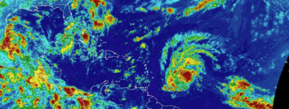
weather watch.png

155 responses to “BB Weather Watch – A Case for Preparation”


  1. Saw some lightning before 7:00 pm.

    Satellite seems to show weather around us.

    Fourteen days left in September, somethings got to give.


  2. My electricity bill hovers around $105. BDS and it is my aim to keep it there.

    ++++++++++++++++++++++++++

    Look at your security night lights if you have them and see what their wattage is.

    Simple fluorescent bulbs can do the job.

    15 watts or so is equivalent to 100 watts incandescent … or so the box says.

    Try to reduce the hours they are on.

    Check and keep checking your refrigerator to make sure it cycles and is not permanently running.

    It runs 24/7 and inefficiencies add up.

    If you have two, or a deep freeze as well, see if you can get by with a simple refrigerator.

    In the days of the exorbitant fuel charge my bill was in the high $200’s.

    It now around $75.00 BDS.

    My bill is estimated and the meter read periodically and sometimes I get credits.

    I also took seriously the advice my parents gave me when I was young.

    If you don’t need a light on, turn it off.

    Probably no sense even considering solar panels.

    If the oil price skyrockets then maybe but there will always be something to cut.

    If I do have to look at solar panels I will look at the minimum ,,,, fridge and security lights.

    I am lucky, the neighbor has bright LED security lights so the areas I like to keep lit at night are lit by those!!

    So mine are off!!


  3. I don’t feel we getting a heat wave.

    We had one last week.

    I feel most days for the balance of the month we will get showers.

    Would live a couple of inches even if we can’t get the balance to make up the average.

    Wind got a bit of a nip in it too.

    Even the lady I was at last night could feel the change in weather for the better.

    Let’s hope it continues.


  4. Would live = would love!!


  5. @ John September 16, 2019 9:36 AM
    “Even the lady I was at last night could feel the change in weather for the better.
    Let’s hope it continues.”
    ++++++++++++++++++++++++++++++++++++++++++++++

    Is that your fornicating “Quaker” way of saying that it was ‘weather for leather’ or- as in your limpidly limp case- sharing licks from your lips?


  6. Actually no … it was the spell checker that gets ahead of itself.

    Looks like the prediction of showers was right so far for today … no thunder as yet.

    Good showers have fallen and are falling where I live.

    … yup there is the thunder.

    Spot on!!

    Forget the heat wave for now!!


  7. Must be the moon!!


  8. Date: 16/09/19 Time: 13:54 UTC
    Air Temp: +27.8° R.H: 84 %
    Winds: 105° at 19 KT

    The 105 degrees relates to the wind direction, not its temperature!!

    This means it is coming out of the South East, off the sea!!

    Right now its a cool 27.8 degrees


  9. Date: 16/09/19 Time: 14:06 UTC
    Air Temp: +27.6° R.H: 84 %
    Winds: 133° at 17 KT

    Six minutes later the wind direction has a more southerly component, 133 degrees.

    Again, this is not the temperature!!

    A few minutes ago the wind speed was 20 Knots.

    This would be considered a fresh breeze on the Beaufort scale.

    … just short of a strong breeze … hence the nip.

    https://en.wikipedia.org/wiki/Beaufort_scale


  10. +27.8° … That’s in centigrade not Farenheit.

    For those who prefer Farenheit, (like me) multiply by 9/5 and add 32!!

    That’s 82.04° Farenheit …. nice and cool for now!!

    https://www.rapidtables.com/convert/temperature/celsius-to-fahrenheit.html

    Good rule of thumb, 30° Centigrade = 86° Farenheit


  11. Date: 16/09/19 Time: 14:21 UTC
    Air Temp: +26.7° R.H: 84 %
    Winds: 108° at 17 KT

    … and now, 15 minutes later the temperature has dropped to 26.7° C or 80.06° F

    It is the Fresh Breeze and the rain that is making this happen.


  12. http://www.barbadosweather.org/

    …… if you want to follow how the temperature and windspeed progress through the day … and week!!


  13. Where has the forecast for a heat wave come from?


  14. David
    September 16, 2019 10:49 AM

    Where has the forecast for a heat wave come from?

    ++++++++++++++++++++++++

    “Meteorologist David Best told the THE NATION that though it would be hot at this stage of the summer season anyway, Barbadians should brace for more stifling heat for “all of next week”.”

    https://www.nationnews.com/nationnews/news/241791/heatwave-coming

    Weather is difficult to predict.

    The source doesn’t actually say “heat wave” …. it is the Nation headlines!!

    Today it is the animals .

    Last week and week before were brutal.

    The nation is 2 weeks late with its prediction, …. hopefully.

    At this time in September we should be getting rain which thankfully we are … for the moment.

    Hopefully the heat wave has come and gone.


  15. Date: 16/09/19 Time: 18:26 UTC
    Air Temp: +28.0° R.H: 84 %
    Winds: 108° at 13 KT

    Wind has dropped a bit for the moment and Temperature is a bit higher, but still so far, under 30° C or 86° F.

    Last week a friend saw 38°C on his car temperature guage.

    So we are about 10° C below last week.

    Maybe the meteorologist needs to be more careful with his choice of words when dealing with reporters looking for a story and seeking to make an impression.

    Last night at Chefette all I could hear was the ladies behind the counter talking about the heat wave coming.

    Perhaps tomorrow or the next day may be hot but for now, be thankful for the reprieve.

    With R.H above 80% if the wind drops we will find it humid.

    BTW, R.H. is an abbreviation for Relative Humidity, not what you might think!!

    So, SS, if you are out in the yard under the tree you may get wet.

    BTW, say hello to the General!!


  16. … reminds me of a couple of stories I heard a while back.

    Somebody told me a “fisherman” appeared on a Call in programme claiming to have passed an iceberg heading to Barbados and reckoned it would pass North Point at 4:00pm that day.

    There was a buzz so he called back and said he had seen some penguins on it.

    Then he went to North Point to see a crowd of Bajans on hand to witness the iceberg!!

    Reminds me also about what some person did to Father Hatch, persuaded him that he had camels in Belleplaine and that people were being cruel to them.

    So Father Hatch begged Bajans to desist from maltreating them.

    “Leave the man’s camels alone”

    Of course, both those stories were probably also themselves made up.

    But I enjoyed them nonetheless.


  17. Hurricane Humberto.

    A Tropical Storm Watch is in effect for…
    * Bermuda


  18. Hello BU family et al,

    So most, if not all of us, are familiar with the hurricane hunters that fly into the systems, do recon, et cetera, et cetera. Some (all?) of the HH aircraft utilize GAIA before/after heading into storms.

    Found this article on one particular mission into Hurricane Hugo (1989). The article recounts the harrowing experiences of one of the hurricane hunter team members as it left BGI in September of 1989. The team also included one Janice Griffith, a reporter (presumably from The Nation?).

    https://www.wunderground.com/resources/education/hugo1.asp

    Rgds,
    Amit.

  19. SirSimpleSimonPresidentForLife Avatar
    SirSimpleSimonPresidentForLife

    @JohnSeptember 16, 2019 3:00 PM “So, SS, if you are out in the yard under the tree you may get wet.”

    Couldn’t garden.

    Couldn’t sit under my trees.

    So I did 5 hours of heavy housekeeping in the morning.

    And kept company with the grands in the afternoon.

    Glad for the rain, and glad for the relief from the heat.


  20. You are most welcome!!


  21. It looks on the satellite as though we could get some serious rain tonight.

    I think the “heat wave” we were having may be broken but we will see.

    Tomorrow should be cool, but who knows, certainly not me..


  22. Once again people looking at satellite photos and PRELIMINARY graphical OUTLOOKS and forming their own opinions and forecasts.Look at the LATEST graphical outlook and see if it is the same.


  23. All systems are WATCHED by the NATIONAL HURRICANE CENTRE in MIAMI.The BARBADOS Met.Service nor ANY OTHER Met Service this part of the GLOBE have the resources and personnel to watch and IDENTIFY ANY weather system approaching.
    Bajans need to stop looking at social media and IGNORE forecasts made by PRESIDENTS,PRIME MINISTERS and’ ADMIRALS’ and log on to the OFFICIAL NATIONAL HURRICANE CENTRE website and READ what they say when systems form until they die.


  24. Agree

    Be wary of what you think are photographs but are really digitally processed images of signals from remote sensors.

    They are not always what they seem.

    We had 24 parts of rain last night whereas the image of the weather approaching us suggested we would wash away!!

    The next system we need to watch is this one.

    “A small low pressure system is located about 1000 miles east of the Lesser Antilles. The associated shower and thunderstorm activity has increased and become a little better organized this morning, and conditions are expected to be conducive for the formation of a tropical depression during the next day or so while the system moves slowly northwestward to west-northwestward.
    * Formation chance through 48 hours…high…90 percent.
    * Formation chance through 5 days…high…90 percent.”

    Haven’t got a latitude as yet as it is still disorganised but it’s westward motion has a northward component which is good for us.

    It is far enough away (~ 1000 miles) that by the time it gets to our longitude it could be north of us but you got to watch and read and listen.

    High pressure in the Atlantic could drive it south to us.

    Latitude, longitude, windspeed and direction of travel first.

    Then look at the pretty pictures.

    … and listen to the advisories which will be coming out of Miami.

    No sign of any heatwave today!!


  25. IIIFFFF it comes our way it will be the last week in September.

    IIIIIFFFF if intensifies into a storm or hurricane it will be an I or a J … or a K, probably I.

    Irma, Ivan

    Janet

    Katrina

    … but then again it could peter out.


  26. Spaghetti models for tropical depression 10 suggest it will go north of us.

    One track has it going through the Dominica area but the rest has it veering north.

    Too early to say so watch.

    Meanwhile another Tropical wave expected to come off the African coast on Thursday!!!

    Keep watching!!


  27. TD 10 is at Latitude 13.4 North and going northwest.

    Expected to become a hurricane in 3 days.

    On the expected track we should be cool but keep an eye!!

    https://hurricane.terrapin.com/ATL-10A/ctrack.html

    Key Messages:

    The depression is expected to strengthen and be a hurricane when
    its moves near the northern Leeward Islands Thursday night and
    Friday, although it is too soon to determine if there will be any
    direct impacts in the islands. Interests there should ensure they
    have their hurricane plan in place and monitor the progress of this
    system.

    FORECAST POSITIONS AND MAX WINDS

    INIT 17/2100Z 13.4N 45.6W 30 KT 35 MPH
    12H 18/0600Z 14.1N 46.9W 35 KT 40 MPH
    24H 18/1800Z 15.0N 48.9W 40 KT 45 MPH
    36H 19/0600Z 15.9N 51.4W 45 KT 50 MPH
    48H 19/1800Z 16.9N 54.1W 55 KT 65 MPH
    72H 20/1800Z 18.9N 60.3W 65 KT 75 MPH
    96H 21/1800Z 20.9N 66.0W 75 KT 85 MPH
    120H 22/1800Z 23.5N 70.5W 80 KT 90 MPH


  28. Source of info

    Tropical Depression Ten Discussion Number 2
    NWS National Hurricane Center Miami FL AL102019
    500 PM AST Tue Sep 17 2019


  29. Yes John,spot on.Wish more people would read the DISCUSSION part of the bulletins out of the NHC…would not understand three quarters of what is said,but,would realize that the experts don’t just look at satellite photos to make predictions.
    By the way, that satellite photo is an OLD photo when it was posted on September 14th.


  30. Nice breeze this morning from the east south east.

    Not as strong as yesterday.

    Date: 18/09/19 Time: 12:27 UTC
    Air Temp: +30.7° R.H: 66 %
    Winds: 113° at 11 KT

    Temperature past 30°/86° so a bit hotter too.

    It’s a storm out there now, Jerry.

    With a storm and its low pressure coming to the area the low pressure in the Atlantic, depending on its location could cause the wind to come from the west.

    At the moment pressure in it is given as 1004 millibars, about 10 millibars below normal atmospheric pressure and it will drop.

    It will be interesting to watch as time progresses.

    Predictions are it will still become a hurricane but conditions will not favour strengthening as much as was predicted yesterday.

    Still, watch. … plus besides the tropical wave due off the African Coast on Thirsday, there is another between it and Jerry.

    They are coming thick and fast so keep an eye on these too!!

    Key Messages:

    Jerry is expected to strengthen and be a hurricane when
    its moves near the northern Leeward Islands Friday, although it is
    too soon to determine if there will be any direct impacts in the
    islands. Interests there should ensure they have their hurricane
    plan in place and monitor the progress of this system.

    FORECAST POSITIONS AND MAX WINDS

    INIT 18/0900Z 14.1N 47.7W 40 KT 45 MPH
    12H 18/1800Z 14.8N 49.4W 45 KT 50 MPH
    24H 19/0600Z 15.7N 52.0W 55 KT 65 MPH
    36H 19/1800Z 16.8N 54.9W 60 KT 70 MPH
    48H 20/0600Z 17.9N 57.9W 65 KT 75 MPH
    72H 21/0600Z 20.2N 64.2W 65 KT 75 MPH
    96H 22/0600Z 22.8N 68.6W 65 KT 75 MPH
    120H 23/0600Z 25.6N 70.2W 65 KT 75 MPH


  31. Tropical Storm Jerry Discussion Number 4
    NWS National Hurricane Center Miami FL AL102019
    500 AM AST Wed Sep 18 2019


  32. Watch it carefully!!

    Here is the picture.

    A slight push south by the appearance of high pressure in the Atlantic is all it takes.

    Next day or so we will know for sure but in 12 hours we will have an indication.

    http://www.barbadosweather.org/GOES16/Jiren_displayer.php?Instrument=GOES16&Product=11um&Sector=ECG&Type=BW&Title=Infrared%2011.2um%20(Long%20wave%20IR%20Band%2014)


  33. … digitally processed image


  34. Date: 18/09/19 Time: 14:58 UTC
    Air Temp: +31.5° R.H: 66 %
    Winds: 108° at 13 KT

    Temperature rising but not out of the ordinary!!

    There is a storm east of us.

    As it gets closer we may or may not get the benefit of some rain!!

    Once it goes north as predicted we won’t get the wind.


  35. https://www.nhc.noaa.gov/xgtwo/two_atl_2d0.png

    ZCZC MIATWOAT ALL
    TTAA00 KNHC DDHHMM

    Tropical Weather Outlook
    NWS National Hurricane Center Miami FL
    200 AM EDT Thu Sep 19 2019

    For the North Atlantic…Caribbean Sea and the Gulf of Mexico:

    The National Hurricane Center is issuing advisories on Hurricane
    Humberto, located a couple hundred miles north-northeast of Bermuda,
    and on Tropical Storm Jerry, located several hundred miles east of
    the Leeward Islands.

    1. A tropical wave located almost 1000 miles west of the Cabo Verde
    Islands is producing disorganized cloudiness and showers. Some
    development of this system is possible while the system approaches
    the Windward Islands this weekend or when it moves across the
    eastern Caribbean Sea early next week.
    * Formation chance through 48 hours…low…near 0 percent.
    * Formation chance through 5 days…low…30 percent.

    2. A large area of disorganized showers and thunderstorms near and to
    the southeast of the Dominican Republic is associated with a
    tropical wave. While upper-level winds are not forecast to be
    conducive for significant development, locally heavy rainfall is
    possible over portions of the Dominican Republic and Haiti during
    the next couple of days. The disturbance is forecast to move slowly
    northwestward through the weekend.
    * Formation chance through 48 hours…low…10 percent.
    * Formation chance through 5 days…low…10 percent.

    Forecaster Latto


  36. A tropical wave is forecast to move off the west coast of Africa
    this weekend. Environmental conditions are expected to be
    conducive for development, and a tropical depression could form
    early next week while the wave moves westward over the eastern
    tropical Atlantic.
    * Formation chance through 48 hours…low…near 0 percent.
    * Formation chance through 5 days…medium…50 percent.

    ++++++++++++++++++++++++++++++++++

    We got to watch this one!!

    5 day formation chance increasing, it was 40% last time I checked.

    So looks like we could be ok this week bar rain from Jerry.


  37. Formation chance through 5 days now up to 70% so we could get another depression headed our way next week


  38. BU bloggers living in Barbados get enough ” early warning ” to prepare for the next storm or hurricane.

    None of you should get caught in line ups for food or gas.


  39. Shower and thunderstorm activity associated with a tropical wave
    located several hundred miles east of the Windward Islands has
    increased during the past 24 hours. The wave is expected to head
    quickly westward at about 20 mph during the next few days and will
    move across the Windward Islands this weekend. Some development is
    possible during that time and a tropical depression could form by
    early next week. Upper-level winds are forecast to become less
    conducive for development next week once the wave moves over the
    eastern Caribbean Sea.
    * Formation chance through 48 hours…low…30 percent.
    * Formation chance through 5 days…medium…40 percent.

    +++++++++++++++++++++++

    Watch this one too, hopefully just rain


  40. https://www.nhc.noaa.gov/xgtwo/two_atl_2d0.png

    ZCZC MIATWOAT ALL
    TTAA00 KNHC DDHHMM

    Tropical Weather Outlook
    NWS National Hurricane Center Miami FL
    200 AM EDT Sat Sep 21 2019

    For the North Atlantic…Caribbean Sea and the Gulf of Mexico:

    The National Hurricane Center is issuing advisories on recently
    downgraded Tropical Storm Jerry, located more than a hundred miles
    north of the northern Leeward Islands.

    1. A tropical wave located several hundred miles east of the Windward
      Islands continues to produce a large area of disorganized showers
      and thunderstorms. Environmental conditions are currently conducive
      for some development, and a tropical depression could form on Sunday
      or early next week while the system moves quickly westward to
      west-northwestward at 15 to 20 mph, crossing the Windward Islands on
      Sunday. Upper-level winds are forecast to become less conducive for
      development by the middle of next week once the wave moves out of
      the northeastern Caribbean Sea. A NOAA Hurricane Hunter aircraft
      is scheduled to investigate this system this afternoon, if
      necessary. Regardless of development, heavy rainfall is possible
      over much of the Lesser Antilles over the weekend, and interests on
      those islands and Puerto Rico should monitor the progress of this
      disturbance.

    * Formation chance through 48 hours…medium…40 percent.
    * Formation chance through 5 days…medium…50 percent.

    1. A broad area of low pressure located just south of Haiti continues
      to produce only disorganized showers and thunderstorms. Due to
      strong upper-level winds, significant development of this system is
      not expected while it moves slowly west-northwestward during the
      next couple of days. Regardless of development, locally heavy
      rainfall is likely over portions of Hispaniola, Jamaica, and Cuba
      through the weekend, potentially causing flash flooding and
      mudslides in areas of high terrain.

    * Formation chance through 48 hours…low…10 percent.
    * Formation chance through 5 days…low…10 percent.

    1. A tropical wave is forecast to move off the west coast of Africa
      by Sunday. Environmental conditions are expected to be conducive
      for development, and a tropical depression or tropical storm is
      likely to form early next week while the wave moves westward across
      the eastern tropical Atlantic.

    * Formation chance through 48 hours…low…30 percent.
    * Formation chance through 5 days…high…90 percent.

    Forecaster Stewart


  41. Some nice looking weather coming in from the East, according to the satellite images.

    Some forecasters are saying thunder showers are likely later today and tomorrow.

    I doubt we can catch up to where our normal September rainfall is but who knows.

    My guage will be the ponds around where I live.

    If they are full, we good but I doubt that very much.

    The rainfall numbers will also tell the story.

    Late next week we will also know if a depression or storm or hurricane is headed our way.

  42. SirSimpleSimonPresidentForLife Avatar
    SirSimpleSimonPresidentForLife

    @JohnSeptember 21, 2019 1:33 PM “My guage will be the ponds around where I live.”

    You will report here once today’s or tomorrow’s rain is done?


  43. Updated: A strong tropical wave, accompanied by a broad low pressure
    area located between Barbados and Tobago, is producing showers and
    thunderstorms that are showing signs of organization. In addition,
    recent satellite-derived surface wind data and observations from
    Barbados indicate that the disturbance is producing winds to near
    tropical storm force in the eastern portion of the system. Further
    development of this disturbance is expected over the next couple of
    days, and a tropical depression or tropical storm will likely form
    while it moves westward and then northwestward at 10 to 15 mph
    across the Windward Islands and over the eastern Caribbean Sea. The
    system is then expected to turn northward, moving near Puerto Rico
    and the Virgin Islands on Tuesday. Regardless of development, heavy
    rainfall and strong gusty winds are likely over much of the Lesser
    Antilles during the next couple of days and will likely spread
    across Puerto Rico and the Virgin Islands by Monday night or
    Tuesday. Interests across the eastern Caribbean should monitor the
    progress of this disturbance since tropical storm watches and
    warnings could be required for portions of the Lesser Antilles and
    Puerto Rico and the Virgin Islands on Sunday.
    * Formation chance through 48 hours…high…70 percent.
    * Formation chance through 5 days…high…70 percent.

    +++++++++++++++++++++++

    On our doorstep!!

    Might get some rain.

    Gusty winds too.

    Right now up to 25 knots.

    Date: 22/09/19 Time: 04:00 UTC
    Air Temp: +27.0° R.H: 86 %
    Winds: 124° at 25 KT

    On the Beaufort Scale a strong breeze, stronger than Dorian when it passed us.

    Strong breeze 22-27 knots
    Large waves with foam crests and some spray.
    Large branches in motion. Whistling heard in overhead wires. Umbrella use becomes difficult. Empty plastic garbage cans tip over.

    Sea probably licking up.

    Not much rain up to midnight, 26 parts so far is nothing to sneeze at but for September, not great.

    Guess we got to wait a little longer in September.

    If this tropical wave between us and Tobago ends up in a strong storm or hurricane and it approaches Puerto Rico and the Virgin Islands from the south it could be serious for them.

    For the moment we don’t have to call an island wide shutdown, …. unless we really want to!!


  44. SirSimpleSimonPresidentForLife
    September 21, 2019 2:35 PM

    @JohnSeptember 21, 2019 1:33 PM “My guage will be the ponds around where I live.”
    You will report here once today’s or tomorrow’s rain is done?

    +++++++++++++++++++

    Day before I asked around about ponds on the Christ Church Dome and a lady pointed to one and told me that in 40 years she had never seen it completely dry as it was for much of the year.

    If we don’t get rain soon real rough times ahead.


  45. We have been experiencing gusty winds much stronger than those associated with Dorian. Not much rain.


  46. Tropical Storm Karen!

    https://www.nhc.noaa.gov/xgtwo/two_atl_2d0.png

    ZCZC MIATWOAT ALL
    TTAA00 KNHC DDHHMM

    Tropical Weather Outlook
    NWS National Hurricane Center Miami FL
    200 AM EDT Sun Sep 22 2019

    For the North Atlantic…Caribbean Sea and the Gulf of Mexico:

    The National Hurricane Center is issuing advisories on Tropical
    Storm Jerry, located several hundred miles south of Bermuda.

    1. Satellite, radar and surface data indicate that the area of low
    pressure located just north of Tobago in the Windward Islands is
    becoming better organized and is producing winds to near tropical
    storm force in the eastern portion of the system. Further
    development of this disturbance is expected over the next couple of
    days, and a tropical depression or tropical storm will likely form
    while it moves west-northwestward and then northwestward at 10 to 15
    mph across the Windward Islands and over the eastern Caribbean Sea.
    The system is then expected to turn northward, moving near Puerto
    Rico and the Virgin Islands on Tuesday. Heavy rainfall and strong
    gusty winds are likely over much of the Leeward and Windward Islands
    during the next couple of days and will spread across Puerto Rico
    and the Virgin Islands by Monday night or Tuesday. Interests across
    the eastern Caribbean should monitor the progress of this low, and
    tropical storm watches and warnings will likely be required for
    portions of the Leeward Islands and Puerto Rico later today. An Air
    Force Hurricane Hunter is scheduled to investigate the system this
    afternoon.
    * Formation chance through 48 hours…high…80 percent.
    * Formation chance through 5 days…high…80 percent.

    2. A strong tropical wave along the west coast of Africa is already
    producing thunderstorm activity that is showing some signs of
    organization. Environmental conditions are conducive for further
    development, and a tropical depression or tropical storm is expected
    to form on Monday or Tuesday while it moves westward to west-
    northwestward across the eastern tropical Atlantic at 15 to 20 mph.
    * Formation chance through 48 hours…high…70 percent.
    * Formation chance through 5 days…high…90 percent.

    Further information on the system near the Windward Islands can be
    found in High Seas Forecasts issued by the National Weather Service
    can be found under AWIPS header NFDHSFAT1, WMO header FZNT01
    KWBC, and online at ocean.weather.gov/shtml/NFDHSFAT1.php

    Forecaster Blake

Leave a Reply to Hal AustinCancel reply

Trending

Discover more from Barbados Underground

Subscribe now to keep reading and get access to the full archive.

Continue reading